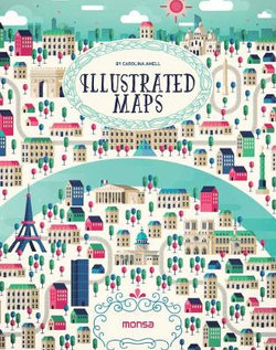
This book is a selection of different ways to interpret a map at the illustrative level. Several artists have created maps of the world s most beautiful places and also its main cities, including Paris, Berlin, Dubai, Rio de Janeiro, and more. They are colorful illustrations in which each artist shows us his or her own way of working with lines and geometrical shapes, some very detailed or synthesized, some using computers or watercolors, and some simply using a pen.
- ISBN:
- 9788416500260
- 9788416500260
-
Category:
- Painting & art manuals
- Format:
- Hardback
- Publication Date:
-
23-06-2016
- Language:
- English
- Publisher:
- Instituto Monsa de Ediciones, S.A.
- Country of origin:
- Spain
- Dimensions (mm):
- 234.95x184.15x20.32mm
- Weight:
- 0.84kg
This title is in stock with our overseas supplier and should arrive at our Sydney warehouse within 3 - 5 weeks of you placing an order.
Once received into our warehouse we will despatch it to you with a Shipping Notification which includes online tracking.
Please check the estimated delivery times below for your region, for after your order is despatched from our warehouse:
ACT Metro: 2 working days
NSW Metro: 2 working days
NSW Rural: 2-3 working days
NSW Remote: 2-5 working days
NT Metro: 3-6 working days
NT Remote: 4-10 working days
QLD Metro: 2-4 working days
QLD Rural: 2-5 working days
QLD Remote: 2-7 working days
SA Metro: 2-5 working days
SA Rural: 3-6 working days
SA Remote: 3-7 working days
TAS Metro: 3-6 working days
TAS Rural: 3-6 working days
VIC Metro: 2-3 working days
VIC Rural: 2-4 working days
VIC Remote: 2-5 working days
WA Metro: 3-6 working days
WA Rural: 4-8 working days
WA Remote: 4-12 working days


Share This Book: